|
||||||
VectrumG - Open interface social platform for Android, GPS navigation, map and group management and real-time information sharing.
We present you the “VectrumG” platform with many innovative features which allows you to manipulate with maps, create and manage groups according to your interests, navigate using GPS with or without Internet connection and share real-time information within public or private groups.
Let’s take an example: you are part of yacht club, then you are sailing at sea. To go there you take a motorbike and moreover you are an ecologist. So you are integrating three groups with different specificities – maps, shared information and people in these groups.
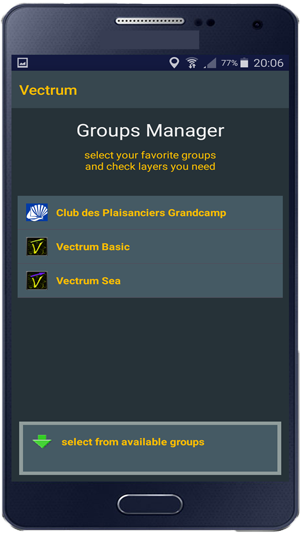
Our platform allows you to add all of these public or private groups at the same time. Besides, it allows you to create and manage groups via our website: VectrumG Platform. You can add the type of information you want to share by associating it with icons that will be visible on the map within your group.
In addition to that, our platform has an open and contextually independent interface, which allows you to attach your own extensions (for example "Vectrum Sea" extension below). In other words, you can add your own maps and / or "layers" while respecting our specifications.
By taking the best of the Vectrum system, VectrumG uses 3D vector maps, an innovative technology in cartography field. With this technology you can style your maps as you want: there are several predefined styles that change the look of the map dynamically depending on your environment luminosity, or you can change them at every moment and personalize your maps further - If you prefer to navigate on the green roads and see purple forests around you, so it is possible!
The default extension remains that of car drivers with 3D maps, whose coverage is global, with respective functionalities.
The basic extension informs you of the situation on the road in real time - the presence of traffic jams, radars, police controls and dangers. So if you notice something, make a simple gesture and signal it so everyone could see it too! If you want to precise the situation leave a voice message with a long click on the bottom. If you want to know the situation in a specified place – place a “spy” – it will show you what is happening there!
In the same way, with the default extension, you can find a parking place (public or private) and pay for it, if necessary, using the applications integrated in your smartphone such as PayByPhone. If you free a place, mark it as "free" to make it easier for everyone to find it!
For the land part, VectrumG offers you the possibility to navigate without the Internet connection by integrating the offline maps provided by Mapsforge.org. So if you don’t have an Internet connection or you just save data, you can change for offline mode. If you want to use maps from Mapsforge.org, you must first download them from Mapsforge.org.
However, to calculate your itinerary you need the Internet connection and once calculated, the browser can guide you in offline mode.
When you share alerts, you can save them if you don’t have an Internet connection, and once you do that, post those alerts. You can also save your itineraries for yourself or to share them.
In fact, by default we do not keep any personal information when sharing alerts. We only keep information about the alerts themselves: GPS coordinates, message, icon, date. To avoid keeping your personal data and identifying you, our system provides you with a single encrypted identifier randomly combined with each connection to our platform.
You can install it directly from Huawei AppGallery (from Google Play Store soon) where it can be adjusted to suite best your Android device (phone, tablet).
Please see our Privacy Policy for the VectrumG entire system and this mobile application -
VectrumG: Privicy Policy
We present you the “VectrumG” platform with many innovative features which allows you to manipulate with maps, create and manage groups according to your interests, navigate using GPS with or without Internet connection and share real-time information within public or private groups.
Innovative technology
VectrumG platform brings an important improvement to the Vectrum navigation system, both in terms of basic functionality but also in principle. Indeed, this platform based on the social principle, allows the creation and management of groups according to points of interest. Concretely, the old Vectrum system refers to only one group - car drivers. Now it is possible to create any group, public or private, in the context of navigation on land, on water or otherwise. Each can belong to several groups at the same time and see / share information within these same groups.Let’s take an example: you are part of yacht club, then you are sailing at sea. To go there you take a motorbike and moreover you are an ecologist. So you are integrating three groups with different specificities – maps, shared information and people in these groups.
Our platform allows you to add all of these public or private groups at the same time. Besides, it allows you to create and manage groups via our website: VectrumG Platform. You can add the type of information you want to share by associating it with icons that will be visible on the map within your group.
In addition to that, our platform has an open and contextually independent interface, which allows you to attach your own extensions (for example "Vectrum Sea" extension below). In other words, you can add your own maps and / or "layers" while respecting our specifications.
By taking the best of the Vectrum system, VectrumG uses 3D vector maps, an innovative technology in cartography field. With this technology you can style your maps as you want: there are several predefined styles that change the look of the map dynamically depending on your environment luminosity, or you can change them at every moment and personalize your maps further - If you prefer to navigate on the green roads and see purple forests around you, so it is possible!
Purpose of the platform
The aim was to create a social sailing platform with an open and contextually independent interface. The principle of groups makes it possible to share specific information with the possibility of using the maps and their own layers. By using the extensions you integrate the context without modifying the source code of the platform. For example we created "Vectrum Sea" for sea navigation, tomorrow we could create "Vectrum Space" for space navigation, or "Vectrum Mars" for navigation on Mars (when GPS on Mars will be available).The default extension remains that of car drivers with 3D maps, whose coverage is global, with respective functionalities.
The basic extension informs you of the situation on the road in real time - the presence of traffic jams, radars, police controls and dangers. So if you notice something, make a simple gesture and signal it so everyone could see it too! If you want to precise the situation leave a voice message with a long click on the bottom. If you want to know the situation in a specified place – place a “spy” – it will show you what is happening there!
In the same way, with the default extension, you can find a parking place (public or private) and pay for it, if necessary, using the applications integrated in your smartphone such as PayByPhone. If you free a place, mark it as "free" to make it easier for everyone to find it!
Optimizing device resources
We have laid particular emphasis on your resources usage optimization (Internet traffic, battery, time) by implementing the new cache system. It is set by default, but you can adjust it as you wish! You can store the geographic zone you are interested in into cache to navigate in offline mode without change map supplier. It is particularly important for sea navigation where Internet does not yet exist.For the land part, VectrumG offers you the possibility to navigate without the Internet connection by integrating the offline maps provided by Mapsforge.org. So if you don’t have an Internet connection or you just save data, you can change for offline mode. If you want to use maps from Mapsforge.org, you must first download them from Mapsforge.org.
However, to calculate your itinerary you need the Internet connection and once calculated, the browser can guide you in offline mode.
When you share alerts, you can save them if you don’t have an Internet connection, and once you do that, post those alerts. You can also save your itineraries for yourself or to share them.
Data protection
Finally, we have laid particular emphasis on personal data protection. Information you share is absolutely anonymous, unless you decide to make it public. This is necessary for Vectrum_covid19 group for example, in order to know who needs help and who wants help.In fact, by default we do not keep any personal information when sharing alerts. We only keep information about the alerts themselves: GPS coordinates, message, icon, date. To avoid keeping your personal data and identifying you, our system provides you with a single encrypted identifier randomly combined with each connection to our platform.
You can install it directly from Huawei AppGallery (from Google Play Store soon) where it can be adjusted to suite best your Android device (phone, tablet).
Please see our Privacy Policy for the VectrumG entire system and this mobile application -
VectrumG: Privicy Policy
Tutorial Group Creation (ex: Food Truck)
|
||||||
Vectrum Sea is an extension created by Ikrosh-Lab which integrates the maritime context, allows to facilitate and secure navigation at sea. This extension is composed of following layers which you can activate or deactivate at any time: bathymetry (relief and sea depths, nature of seabed, place names, markup, surface hydrodynamic, waves, wind and tides. These layers are of three types:
For the moment the extension covers the French coasts - Atlantic part and La Manche.
Static layers:
This is for example the bathymetry - the depths and relief, the nature of the seabed (sand, rocks, gravel ...), or place names. This information will never change, at least in the near future.Interactive layers:
The markup is one of them, it rarely changes so this layer is considered as static, but you can see more information by clicking on the icon - its name, the lights’ presence, etc.Dynamic layers:
Dynamic layers actively interact with the user. You will be able to see the latest information, but also the forecast for 5 days. This is for example the surface hydrodynamic layer - its speed, flow direction, as well as water temperature; waves - height and direction; weather - wind speed and direction.For the moment the extension covers the French coasts - Atlantic part and La Manche.


